
🌍
English


RV Maps & Earth


- Author: rvelices
- Categories: Plugin
- Tags: google, maps
- First revision date: 2007-05-10
- Latest revision date: 2018-07-23
- Available languages: 26 (see)
- Compatible with: Piwigo releases 1.7, 2.0, 2.1, 2.2, 2.3, 2.4, 2.5, 2.6, 2.7, 2.8, 2.9, 2.10, 11
- Downloads: 138940
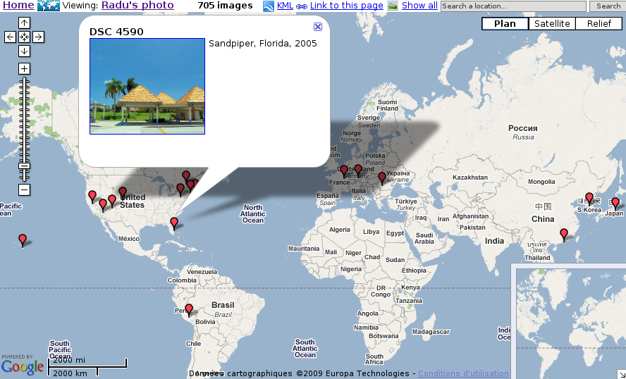
About: Extends Piwigo with geographical location for each photo. View your photos with Google Maps, or open them in Google Earth.
- View by category, by tag, search results or recent pictures.
- Server side clustering of multiple photos, depending on the map bounds and location (to avoid hundreds of markers)
- View all photos in the current map bounds or around a map marker
- Manually set the latitude and longitude on the administration page or synchronize the location with the gps exif metadata
- This plugin does not require any php/template or css code modification, but it does modify the database.
Instructions: Unzip the file in plugins subdirectory of your gallery, then install and activate the plugin from the admin page. Or install from the Plugins menu.
Related links
- Github page: source code, bug/request tracker
Revision list
Revision 2.10.b
9056 Downloads, Released on 2018-07-23
Revision 2.10.a
4370 Downloads, Released on 2017-10-08
Revision 2.9.a
2716 Downloads, Released on 2017-08-21
Revision 2.8.a
5214 Downloads, Released on 2016-08-22
Revision 2.7.b
4580 Downloads, Released on 2016-01-26
Revision 2.7.a
6946 Downloads, Released on 2014-09-03
Revision 2.6.a
5586 Downloads, Released on 2014-01-17
Revision 2.5.c
5171 Downloads, Released on 2013-06-08

Compatible with: 2.5
New languages: Dansk [DK]Brasil [BR]中文 (简体) [CN]Türkçe [TR]Ελληνικά [GR] Total : 23
- admin can choose default map type (roadmap, satellite, ...)
- auto center and zoom when viewing map for the entire gallery
- fix kml namespace
- attempt to fix uage with https on the photo page (need test)
Revision 2.5.b
3705 Downloads, Released on 2013-04-15
Revision 2.5.a
3530 Downloads, Released on 2013-02-27
Revision 2.4.g
4279 Downloads, Released on 2012-11-05
Revision 2.4.f
3141 Downloads, Released on 2012-10-24
Revision 2.4.e
3090 Downloads, Released on 2012-10-12
Revision 2.4.d
3092 Downloads, Released on 2012-09-25
Revision 2.4.c
3496 Downloads, Released on 2012-08-09
Revision 2.4.b
3589 Downloads, Released on 2012-06-19
Revision 2.4.a
2829 Downloads, Released on 2012-04-16
Revision 2.3.b
4843 Downloads, Released on 2011-12-11
Revision 2.3.a
3367 Downloads, Released on 2011-10-06
Revision 2.2.b
4419 Downloads, Released on 2011-02-08
Revision 2.2.a
2804 Downloads, Released on 2011-01-24
Revision 2.1.b
4030 Downloads, Released on 2010-09-28
Revision 2.1.a
3695 Downloads, Released on 2010-05-27
Revision 2.0.d
3524 Downloads, Released on 2010-03-01
Revision 2.0.c
3695 Downloads, Released on 2009-10-20
Revision 2.0.b
3775 Downloads, Released on 2009-06-23
Revision 2.0.a
4367 Downloads, Released on 2009-02-03
Revision 1.7.h
3257 Downloads, Released on 2008-08-28
Revision 1.7.g
3330 Downloads, Released on 2008-02-13
Revision 1.7.f
3153 Downloads, Released on 2008-01-20
Revision 1.7.e
3230 Downloads, Released on 2007-09-08
Revision 1.7.d
3208 Downloads, Released on 2007-06-21
Revision 1.7.c
3223 Downloads, Released on 2007-05-24
Revision 1.7.b
3214 Downloads, Released on 2007-05-15
Revision 1.7.a
3416 Downloads, Released on 2007-05-10