
🌍
English


RV Maps & Earth


- Author: rvelices
- Categories: Plugin
- Tags: google, maps
- First revision date: 2007-05-10
- Latest revision date: 2018-07-23
- Available languages: 26 (see)
- Compatible with: Piwigo releases 1.7, 2.0, 2.1, 2.2, 2.3, 2.4, 2.5, 2.6, 2.7, 2.8, 2.9, 2.10, 11
- Downloads: 138944
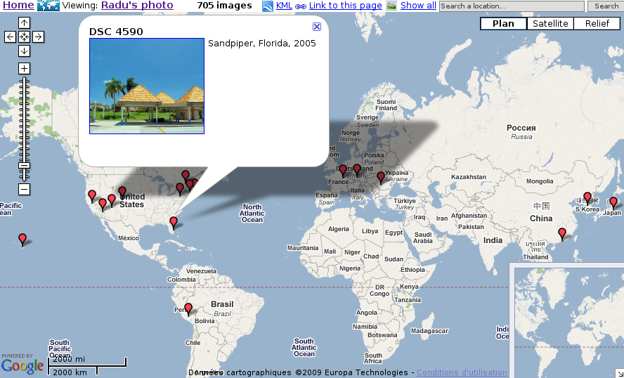
About: Extends Piwigo with geographical location for each photo. View your photos with Google Maps, or open them in Google Earth.
- View by category, by tag, search results or recent pictures.
- Server side clustering of multiple photos, depending on the map bounds and location (to avoid hundreds of markers)
- View all photos in the current map bounds or around a map marker
- Manually set the latitude and longitude on the administration page or synchronize the location with the gps exif metadata
- This plugin does not require any php/template or css code modification, but it does modify the database.
Instructions: Unzip the file in plugins subdirectory of your gallery, then install and activate the plugin from the admin page. Or install from the Plugins menu.
Related links
- Github page: source code, bug/request tracker
Revision list
Revision 2.10.b
9057 Downloads, Released on 2018-07-23
Revision 2.10.a
4370 Downloads, Released on 2017-10-08
Revision 2.9.a
2716 Downloads, Released on 2017-08-21
Revision 2.8.a
5214 Downloads, Released on 2016-08-22
Revision 2.7.b
4580 Downloads, Released on 2016-01-26
Revision 2.7.a
6946 Downloads, Released on 2014-09-03
Revision 2.6.a
5586 Downloads, Released on 2014-01-17
Revision 2.5.c
5171 Downloads, Released on 2013-06-08
Revision 2.5.b
3705 Downloads, Released on 2013-04-15
Revision 2.5.a
3530 Downloads, Released on 2013-02-27
Revision 2.4.g
4279 Downloads, Released on 2012-11-05
Revision 2.4.f
3142 Downloads, Released on 2012-10-24
Revision 2.4.e
3090 Downloads, Released on 2012-10-12
Revision 2.4.d
3092 Downloads, Released on 2012-09-25
Revision 2.4.c
3496 Downloads, Released on 2012-08-09
Revision 2.4.b
3589 Downloads, Released on 2012-06-19
Revision 2.4.a
2829 Downloads, Released on 2012-04-16
Revision 2.3.b
4843 Downloads, Released on 2011-12-11
Revision 2.3.a
3367 Downloads, Released on 2011-10-06
Revision 2.2.b
4420 Downloads, Released on 2011-02-08
Revision 2.2.a
2804 Downloads, Released on 2011-01-24
Revision 2.1.b
4030 Downloads, Released on 2010-09-28
Revision 2.1.a
3695 Downloads, Released on 2010-05-27
Revision 2.0.d
3524 Downloads, Released on 2010-03-01
Revision 2.0.c
3695 Downloads, Released on 2009-10-20
Revision 2.0.b
3775 Downloads, Released on 2009-06-23
Revision 2.0.a
4367 Downloads, Released on 2009-02-03
Revision 1.7.h
3257 Downloads, Released on 2008-08-28
Revision 1.7.g
3330 Downloads, Released on 2008-02-13
Revision 1.7.f
3153 Downloads, Released on 2008-01-20
Revision 1.7.e
3230 Downloads, Released on 2007-09-08
Revision 1.7.d
3209 Downloads, Released on 2007-06-21
Revision 1.7.c
3223 Downloads, Released on 2007-05-24

Compatible with: 1.7
- the map page opened from the picture page is not on google anymore
- the picture map page has a link "More pictures near this location"
- allow custom markers instead of the default one
- on startup, the map page is automatically centered and zoomed to the images (all cases except when viewing the entire gallery or when an url generated by Link to this page is used)
- improved link to this page for different map types
- security: checks for guests for galleries that do not allow visits as guest
- security: checks for adivser administrators
- javascript improvements to avoid memory leaks in IE
Revision 1.7.b
3214 Downloads, Released on 2007-05-15
Revision 1.7.a
3416 Downloads, Released on 2007-05-10